Stó:lo Territory:
East Lower Mainland and south Fraser Canyon areas of southwestern
British Columbia plus a tiny sliver of northwest Washington State.
Portals
|
. |
Stó:lo Nation
Chilliwack, British Columbia
CHEHALIS
DIVISION:
(Click for UPPER CHEHALIS)
Sts’ailes Band
Chehalis, British Columbia (Non-Stó:lo)
NICOMEN
DIVISION:
Leq'á:mel / Lakahahmen First Nation
Deroche, British Columbia
PILALT
DIVISION:
Cheam First Nation
Rosedale, British Columbia
Shxwhá:y Village
Chilliwack, British Columbia
Skwah First Nation
Chilliwack, British Columbia
SCOWLITZ
DIVISION:
Sq'éwlets First Nation
Lake Errock, British Columbia
SUMAS
DIVISION:
Sumas First Nation
Abbotsford, British Columbia
TAIT
DIVISION:
Chawathil First Nation / Hope Band
Hope, British Columbia
Peters First Nation
Hope, British Columbia
Seabird Island / Sqewqel Band
Agassiz, British Columbia
Shxw’owhámel First Nation
/ Ohamil Band
Hope, British Columbia
Sq`ewá:lxw / Skawahlook First
Nation
Agassiz, British Columbia
TS'ELXWEYEQW
DIVISION:
Ch'iyaqtel / Tzeachten First Nation
Chilliwack, British Columbi
Skowkale First Nation
Chilliwack, British Columbia
Soowahlie Band
Cultus Lake, British Columbia
Squiala First Nation
Chilliwack, British Columbia
Ts'elxweyeqw / Chilliwack Tribe
Chilliwack, British Columbiaa |
|
Stó:lo Population
Canada (2020) - 8,300
United States (2020) - 0 |
S
A L I S H COAST
COMMENTS
Halq'emeylem is a dialect
of the Coast Salish Halkomelem language. Generally, the Halq'emeylem
speaking people call themselves "Stó:lo", or
Upriver People. However, there are two First Nations who are
politically separate, the Sts'ailes and Yale, who do not
refer to themselves as "Stó:lo".
Nlaka'pamux Border: Is between Spuzzum and Yale B.C. is
where the Fraser Canyon narrows. This was a prime salmon fishing
location used everyone in the region including Halkomelem speaking
First Nations from as far away as Vancouver Island. The Nlaka'pamux
are quite particular to mention that their territory includes
the mountainous region east of Yale/Hope and then southwest into
the United States as far as Mount Baker. The Ts'elxweyeqw Tribe
map boundary corresponds with this...and dips down into within
the United States in the process.
Nooksack Border: Generally, this follows the Canada-US
border in the Lower Mainland flatlands. The critical element
here is that there is a section of Nooksack Territory that juts
up into Canada southwest of Abbotsford. Conversely, there is
a section of Sumas Sto:lo Territory that extends down into the
U.S.
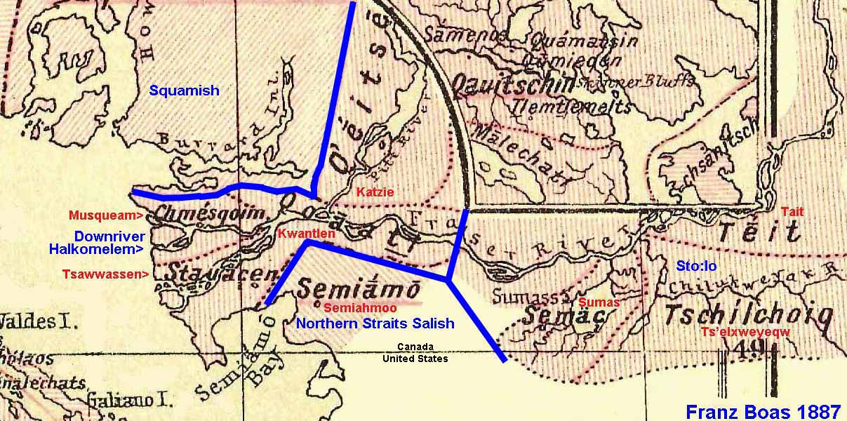
Downriver Halkomelem Border: This is determined by which First Nation
in the central Lower Mainland speaks which dialect. Since the
Matsqui speak Halq'emeylem and the Kwantlen speak Hun'qumi'nun,
south of the Fraser River, the western border is where their
territories meet. North of the Fraser River, the border is between
the Skayuk and Whonnock First Nations. Officially, the Whonnock
are part of the Kwantlen Band. This border may have actually
been even further to the east, but since the Skayuk and Hatzic
Bands became extinct in the 1782 smallpox epidemic and it is
unconfirmable.
Complication #1: It is said
that the Skayuk were an isolated Squamish Band living amongst
the Halq'emeylem.
Complication #2: At the time
of first contact, the Snohomish Band extended from north of White
Rock all the way up to the Whonnock area. The Kwantlen lived
further downstream at that time. So, perhaps it was the Hun'qumi'nun-speaking
Snohomish Band who actually bordered the Halq'emeylem. (Devastated
in a smallpox epidemic, the Snohomish eventually merged with
the Straits Salish Semiahmoo Band.)
Complication #3: The Kwantlen
are the only Hun'qumi'nun speaking members of the Halq'emeylem
Stó:lo Tribal Council.
Complication #4: If you visit
the Kwikwetlem First Nation website, it states prominently that
the they speak "Halq'emeylem". This conflicts with
assessment of the authoritative First
Peoples Language Map project. What's going here is that the
term "Halq'emeylem" is sometimes used to refer to both
the upriver and downriver dialects.
Complication #5: Very often
you will see maps of Stó:lo Territory which include First
Nations at the Lower Mainland shores of the Pacific Ocean. However,
the Tsawwassen, Musqueam, and Tsleil-Waututh do not regard themselves
as Stó:lo.
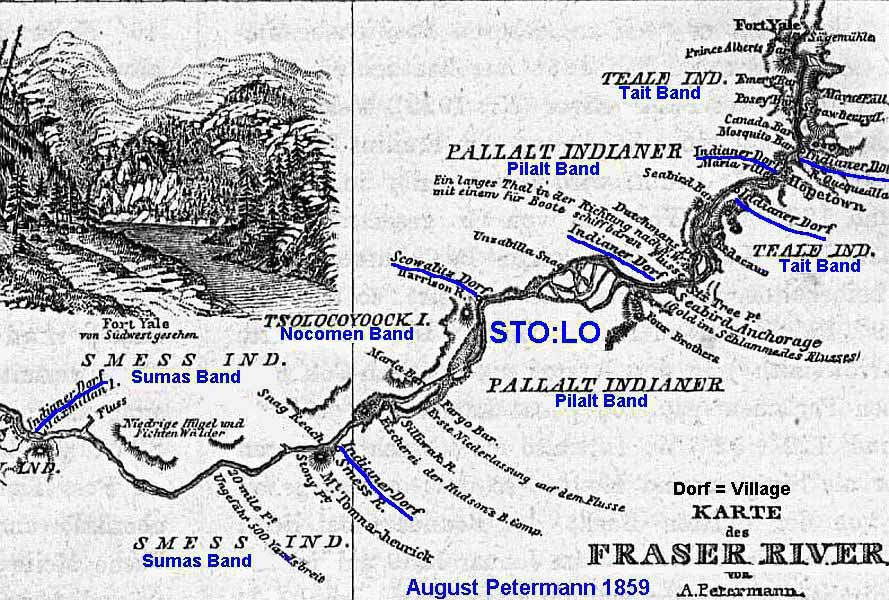
St'át'imc Border: Twenty kilometers north of Lake Harrison.
This area was originally inhabited by the Halq'emeylem speaking
Sts'ailes (St'qwompth Division). When the 1858 Gold Rush began,
Lake Harrison became a prime route for the transport of the Gold
miners and their supplies. Being hostile, the Sts'ailes were
regarded as unsuited for packing work. Presumably they were evicted
from the region, and St'át'imc packers were brought in
to do the work. The St'át'imc remain to this day and have
formed the In-shuck-ch Nation. |